Wednesday, March 10, 2010
2010 El Nino Reduces Marine Life
 The ongoing El Niño of 2010 is reducing marine populations according to scientists at NOAA and Scripps Institution of Oceanography.
 Researchers are reporting a stronger than normal northward movement of warm water up the Southern California coast, a high sea-level event in January and low abundances of plankton and pelagic fish - all conditions consistent El Niño.
Sea surface temperatures along the entire West Coast of America are 0.5 to 1 degree Celsius (0.9 to 1.8 degrees Fahrenheit) warmer than normal and at points off Southern California are as much as 1.6 degrees Celsius (2.9 degrees Fahrenheit) higher than normal. The most unusually high temperatures were mapped around Catalina and San Clemente islands.
The high coastal sea levels may be caused by strong winter storms, scientists are investigating whether this is the case or whether they are primarily a result of El Niño.
A combination of satellite remote sensing and field measurements is offering scientists a broader view of the evolution of this El Niño that was not available during previous El Niños, which were especially strong in 1982-83 and 1997-98.
The two research centres use data collected by satellites and buoy-mounted instruments to measure sea surface temperature. Researchers embark on quarterly cruises off the California coast to collect vertical temperature profiles in the upper reaches of the water column. They also count eggs of commercially important fishes such as sardines and anchovies as well as measure plankton volumes to estimate the amount of "production" available to marine organisms. NOAA's Advanced Survey Technologies Group assesses fish populations through acoustic surveys. In contrast with the last major El Niño, Scripps now deploys Spray gliders, diving robots that now gather ocean temperature and other data.
The scientists have observed a drop in biological abundance, or productivity, that appears to be related to the northward movement of warm water from the equator. The flow arrives in pulsing Kelvin waves that are detected by sea level and altimeter monitors and coastal tidal gauges. The layer of warm water often stifles the upwelling of nutrients from lower ocean depths that sustain larger populations of fishes and invertebrates.
A Kelvin wave is a gentle yet massive swell of warm water travelling across the Pacific from West to East. A typical Kelvin wave is 5 or 10 cm high, hundreds of kilometers wide, and a few degrees warmer than surrounding waters.
If El Niño conditions continue, they are likely to be characterized by weaker than normal upwelling and lower biological production. El Niño conditions are forecast to persist into spring. If so, they may result in fewer fish and breeding failure of seabirds.
Further Reading
A Curious Pacific Wave, Science@NASA
Scripps Institution of Oceanography
Labels: environment, SCUBA News, USA
Monday, February 22, 2010
Sea of Cortez Threatened
 Life in the Sea of Cortez is endangered by destructive new fishing methods.
Ten years ago graduate students Octavio Aburto-Oropeza and Gustavo Paredes surveyed the marine life of the Sea of Cortez (also known as the Gulf of California). In 2009 they went back and were shocked at how things had declined. Sixty percent of the surveyed sites showed signs of degradation, according to Aburto-Oropeza, and many are now missing the top predators normally present in healthy, functioning ecosystems.
"Ten years later we can actually measure the effects of not putting conservation measures in place," Paredes told Explorations Magazine. "Some of us had been conducting surveys in certain sites every year, but until this year we didn't know the whole story of what was going on."
The changes have occurred because of fishing. Traditional hook-and-line fisherman have been put out of business by vastly more damaging gill net fishing and "hookah" diving. Hookah fishermen use surface-supplied air through piping that allows them to walk along the seafloor for long periods of time. The technique is typically conducted at night when fish are resting, allowing the hookah fishermen to spear or grab large numbers of vulnerable fish and invertebrates.
In the most dramatic example of fishing impacts observed on the 2009 expedition a survey of San Esteban Island in the north revealed reefs devoid of fish and instead covered by mats of cyanobacteria.
There are areas which have flourished, though. One example is Cabo Pulmo near the southern tip of the Baja peninsula. Fishing restrictions there since 1995 have ensured that Cabo Pulmo retains a mix of sea life and flourishing fish populations. Other successes include Coronado Island inside the Loreto marine park and Los Islotes inside Espiritu Santo marine park.
Using compressed air has been banned in Mexico for sports fishermen for 40 years, but since commercial fishermen weren’t named specifically they had been allowed to use compressed air to clean the reef. In May 2009 this changed: the use of hookahs have now been outlawed for any type of fishing. Illegal fishing still goes on though, and environmental organisation Sea Watch is asking people to report any that they encounter at http://seawatch.org/en/Resource-Library/359/report-illegal-fishing
Further Reading:
Scripps Institution of Oceanography
Labels: dive destination, environment, research, SCUBA diving, SCUBA News, SCUBA Travel
Monday, January 04, 2010
Acoustic Tools Help Whales
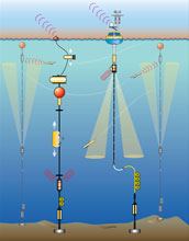
 New acoustic sensors are being used in research and conservation projects around the world, with some very important practical results. Among them is improved monitoring of endangered North Atlantic right whales in an effort to reduce ship strikes, a leading cause of their deaths.
Sofie Van Parijs is one of many researcher whose work is decribed this month in the journal Marine Ecology Progress Series. Her paper is one of about a dozen in a special theme issue focused on acoustics in marine ecology. Van Parijs, who currently heads the NEFSC's Protected Species Branch, is also a co-author of a related paper on acoustic interference or masking, in which marine animals alter their use of sound as a result of changing background noise.
Van Parijs and her colleagues focus on two types of acoustic sensors, real-time and archival. Real-time sensors are mounted on surface buoys, usually anchored or cabled to the ocean bottom, or deployed as arrays towed from a surface vessel. Archival sensors are affixed on bottom-moored buoys equipped with hydrophones to continuously record ocean sounds for long periods of time, often up to three months, before the sensors are temporarily recovered and their batteries refreshed. Some archiving sensors can be mounted of individual animals.
“Marine animals live their lives and communicate acoustically across different time and space scales and use sound for different reasons,” said Van Parijs. “We need to use the right tool in the right place for the right need. There is no ‘one size fits all’ when it comes to using technology in the ocean.”
Large whales move and communicate over great distances, while smaller whales and dolphins tend to communicate over smaller areas. Pinnipeds, the group of marine mammals that includes seals, walrus and sea lions, can breed on land, on ice or in the water, and move and communicate from small to medium distances. Human-produced sounds complicate the sensing problem by adding sounds to what can be a very noisy environment.
The use of passive acoustic monitoring is increasing as improved reliability and lower hardware and software costs provide researchers with a set of tools that can answer a broad range of scientific questions. This information can, in turn, be used in conservation management and mitigation efforts. While most of the new technologies have been applied in studies of whales and dolphins, the researchers say the sensors can also be used in studying pinnipeds, sirenians (manatees and dugongs) and fish.
Further Reading: Northeast Fisheries Science Center
What do you think of this news item? Join a discussion.
Labels: environment, technology, whale and dolphins
Thursday, December 10, 2009
IUCN warns of acid oceans
 Increased release of carbon dioxide in the atmosphere is making seawater more acidic and is threatening ecosystems and species. It is also reducing the ocean’s ability to absorb carbon dioxide and regulate climate. According to IUCN (International Union for Conservation of Nature), deep and immediate cuts in emissions are needed to stall the acidification of oceans and prevent mass extinction of marine species.
There can be little doubt that the ocean is undergoing dramatic changes that will impact many human lives now and in coming generations, unless we act quickly and decisively. Previous episodes of ocean acidification were linked to mass extinctions of some species and it is reasonable to assume that this episode could have the same consequences.
The ocean provides about half of the Earth’s natural resources and humankind takes direct advantage of this through our fisheries and shellfisheries. The ocean also absorbs 25 percent of all the carbon dioxide we emit each year, and produces half the oxygen we breathe.
Ocean acidity has increased by 30 percent since industrialisation began 250 years ago. If CO2 levels in the atmosphere continue to rise, sea water acidity could increase by 120% by 2060 – greater than anything experienced in the past 21 million years. By 2100, 70% of cold water corals may be exposed to corrosive water.
Given the lag between CO2 emissions and a stabilisation of acidification, it could take tens of thousands of years before the ocean’s properties are restored and even longer for full biological recovery. This demands immediate and substantial emissions cuts and technology that actively removes CO2.
“There is an increasingly real and very urgent need to dramatically cut emissions. The ocean is what makes Earth habitable and different from anywhere else we know in our solar system and beyond – now’s the time to act to minimise the impacts on our life support system while we still have time,” says Carl Gustaf Lundin, Head of IUCN’s Global Marine Programme.
Further Reading
Ocean Acidification - The Facts.
What do you think of this news item? Join a discussion.
Labels: environment, research, SCUBA News
Wednesday, November 11, 2009
Swarms of ocean robots to monitor oil spills
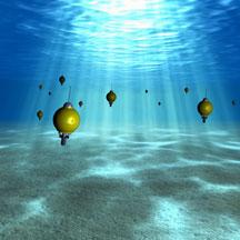 Swarms of miniature robotic ocean explorers that could one day help predict where ocean currents will carry oil spills, and which marine areas should be protected.
These autonomous underwater drifters will trace the fine details that can determine underwater ocean currents of a few kilometers. These are important for understanding marine protected areas, algal blooms, oil spills and the path sewage takes after it is pumped into the ocean.
"Maybe there has been an oil spill in the ocean and we want to establish very quickly how and where the spill might move. We are developing the algorithms that will keep a swarm of autonomous underwater explorers (AUEs) coordinated so they can follow the flow of the ocean currents and give us data on the spill as it is moving around," explained Jorge Cortes, a professor in the Mechanical and Aerospace Engineering Department at the UC San Diego Jacobs School of Engineering.
In addition to predicting where oil will travel, scientists can use this information on the flow of ocean currents in order to improve their models—and ultimately their understanding—of how ocean currents operate on the scale of kilometers and what this means for ocean life and for determining where marine protected areas should be established.
According to Jules Jaffe and Peter Franks, the two Scripps Institution of Oceanography researchers, the robot swarms could aid in science’s development of marine protected areas by following currents for determining critical nursery habitats and for tracking harmful blooms of algae.
The project differs from related work on networks of underwater robots in that the robot swarms the UCSD researchers are developing are significantly smaller and less expensive. At the same time, these robot swarms will be far more capable of making use of the information they collect on the fly in order to improve the accuracy of their task at hand.
Small armies of such robots will concurrently map currents and sense the environment. The robots relay their sensed data when they surface.
The robots will work through a system under which several football sized devices are deployed in conjunction with many—tens or even hundreds—of pint-sized underwater explorers. As they move about the ocean, the smaller-sized robots will use acoustic transmissions from the "motherships" to ascertain their positions. Collectively, the entire swarms of robots will help track fine ocean currents and flows that organisms at the small scale, tiny abalone larvae, for example, experience in the ocean.
"AUEs (Autoonomous Underwater Explorers) will give us information and statistics to figure out how the small organisms survive, how they move in the ocean and the physical dynamics they experience as they get around," said Franks. "AUEs should improve our ocean models and eventually allow us to do a better job of following the weather and climate of the ocean, as well as help us understand things like carbon fluxes."
Franks, who conducts research on marine phytoplankton, among other areas, says the new concentration on dense sampling at small scales will help resolve some of the patchiness in understanding the physical and biological properties on those scales.
"Plankton are somewhat like the balloons of the ocean floating around out there," he said. "We are trying to figure out how the ocean works at the scales that matter to the plankton. You put 100 of these AUEs in the ocean and let 'er rip. We'll be able to look at how they spread apart and how they move to get a sense of the physics driving the flow."
Further Reading:
UC San Diego Jacobs School of Engineering
National Science Foundation
Ocean Research Robots: A Future Vision for Ocean Observation
What do you think of this news item? Join a discussion.
Labels: environment, research, SCUBA News, technology
Friday, November 06, 2009
NSF Launches Ocean Observatories Initiative
 The National Science Foundation has announced agreement for vast undersea observing network. Called the Ocean Observatories Initiative (OOI) it will provide a network of undersea sensors for observing complex ocean processes such as climate variability, ocean circulation and ocean acidification at several coastal, open-ocean and seafloor locations.
Continuous data flow from hundreds of OOI sensors will be integrated by a sophisticated computing network, and will be openly available to scientists, policy makers, students and the public.
Advanced ocean research and sensor tools are a significant improvement over past techniques. Remotely operated and autonomous vehicles go deeper and perform longer than submarines. Underwater samplers do in minutes what once took hours in a lab. Telecommunications cables link experiments directly to office computers on land. At sea, satellite uplinks shuttle buoy data at increasing speeds.
What do you think of this news item? Join a discussion.
Labels: environment, SCUBA News, technology
Friday, October 09, 2009
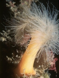
Creature of the Month: Plumose Anemone
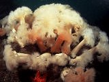
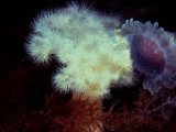
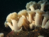 Plumose anemones (Metridium senile) occur in large numbers in good diving areas in temperate waters. They comprise a tall, smooth column topped with a crown of feathery tentacles. When they contact they look like swirly blobs, as can be seen in our photograph.
Individuals may be white, orange, green or blue in colour. They grow up to 30 cm tall and 15 cm across at the base. They like areas with currents so tend to live on prominent pieces of wrecks or on rocky pinnacles.
 With fine, delicate tentacles they are unsuited to capturing large animals like fish. Instead they specialise in smaller prey such as small planktonic crustaceans. The anemone's columnar body is narrower just below the tentacles. A current will bend the stalk at this point and expose the tentacles broadside to the flow in the best position for feeding on suspended matter.
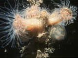 The Plumose anemone occurs from the Bay of Biscay (North of Spain) to Scandinavia in the northeast Atlantic, and on the west and east coasts of North America. It is unknown from the western basin of the Mediterranean but has been seen in the Adriatic, where it is believed to have been introduced. It has also been seen in Table Bay Harbour in South Africa where it was probably introduced from Europe.
Further Reading:
Great British Marine Animals, by Paul Naylor
Ask Nature
What do you think of this news item? Join a discussion.
Labels: environment, Europe, marine biology, SCUBA diving, SCUBA News, SCUBA Travel, UK
Monday, September 21, 2009
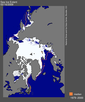
Arctic Sea Ice Reaches 2009 Low
While this year's September minimum extent was greater than each of the past two record-setting and near-record-setting low years, it is still significantly below the long-term average and well outside the range of natural climate variability, said NSIDC Research Scientist Walt Meier. Most scientists believe the shrinking Arctic sea ice is tied to warming temperatures caused by an increase in human-produced greenhouse gases being pumped into Earth's atmosphere.
Atmospheric circulation patterns helped the Arctic sea ice spread out in August to prevent another record-setting minimum, said Meier. But most of the 2009 September Arctic sea ice is thin first- or second-year ice, rather than thicker, multi-year ice that used to dominate the region, said Meier.
The minimum 2009 sea-ice extent is still about 620,000 square miles below the average minimum extent measured between 1979 and 2000 -- an area nearly equal to the size of Alaska, said Meier. "We are still seeing a downward trend that appears to be heading toward ice-free Arctic summers," Meier said.
Further Reading:
National Snow and Ice Data Center
What do you think of this news item? Join a discussion.
Labels: environment, research, SCUBA News
Friday, September 11, 2009
Rare Algae Saves Caribbean Coral
 A rare opportunity has allowed a team of scientists to evaluate corals--and the essential, photosynthetic algae that live inside their cells--before, during, and after a period in 2005 when global warming caused sea-surface temperatures in the Caribbean to rise.
The team, led by Penn State biologist Todd LaJeunesse, found that a rare species of algae that is tolerant of stressful environmental conditions proliferated in corals at a time when more sensitive algae that usually dwell within the corals were being expelled.
Certain species of algae have evolved over millions of years to live in symbiotic relationships with species of corals. These photosynthetic algae provide the corals with nutrients and energy, while the corals provide the algae with a place to live.
"There is a fine balance between giving and taking in these symbiotic relationships," said LaJeunesse.
Symbiodinium trenchi is normally a rare species of algae in the Caribbean, according to LaJeunesse. "Because the species is apparently tolerant of high or fluctuating temperatures, it was able to take advantage of a 2005 warming event and become more prolific."
Symbiodinium trenchi appears to have saved certain colonies of coral from the damaging effects of unusually warm water.
"As ocean temperatures rise as a result of global warming, we can expect this species to become more common and persistent," said LaJeunesse. "However, since it is not normally associated with corals in the Caribbean, we don't know if its increased presence will benefit or harm corals in the long term."
If Symbiodinium trenchi takes from the corals more than it gives back, over time the corals' health will decline.
In 2005, sea surface temperatures in the Caribbean rose by up to two degrees Celsius above normal for a period of three to four months, high enough and long enough to severely stress corals.
The process of damaged or dying algae being expelled from the cells of corals is known as bleaching because it leaves behind bone-white coral skeletons that soon will die without their symbiotic partners.
Although Symbiodinium trenchi saved some corals from dying in 2005, LaJeunesse is concerned that the species might not be good for the corals if warming trends continue and Symbiodinium trenchi becomes more common.
"Because Symbiodinium trenchi does not appear to have successfully co-evolved with Caribbean coral species, it may not provide the corals with adequate nutrition," he said.
The research was published in the online version of the journal Proceedings of the Royal Society B on September 9, 2009.
What do you think of this news item? Join a discussion.
Labels: Caribbean, coral, environment, marine biology, research, SCUBA News
Saturday, August 15, 2009
Warming Ocean Contributes to Global Warming
Scientists at the National Oceanography Centre Southampton working in collaboration with researchers from the University of Birmingham, Royal Holloway London and IFM-Geomar in Germany have found that more than 250 plumes of bubbles of methane gas are rising from the seabed of the West Spitsbergen continental margin in the Arctic, in a depth range of 150 to 400 metres.
Methane released from gas hydrate in submarine sediments has been identified in the past as an agent of climate change.
The data were collected from the royal research ship RRS James Clark Ross, as part of the Natural Environment Research Council’s International Polar Year Initiative. The bubble plumes were detected using sonar and then sampled with a water-bottle sampling system over a range of depths.
The results indicate that the warming of the northward-flowing West Spitsbergen current by 1 degree over the last thirty years has caused the release of methane by breaking down methane hydrate in the sediment beneath the seabed.
Professor Tim Minshull, Head of the University of Southampton’s School of Ocean and Earth Science based at the National Oceanography Centre, says: “Our survey was designed to work out how much methane might be released by future ocean warming; we did not expect to discover such strong evidence that this process has already started.”
Graham Westbrook Professor of Geophysics at the University of Birmingham, warns: “If this process becomes widespread along Arctic continental margins, tens of megatonnes of methane per year – equivalent to 5-10% of the total amount released globally by natural sources, could be released into the ocean.”
Journal Reference:
Westbrook, G. K., et al. (2009), Escape of methane gas from the seabed along the West Spitsbergen continental margin, Geophys. Res. Lett., 36, L15608, doi:10.1029/2009GL039191.
What do you think of this news item? Join a discussion.
Labels: environment, research, SCUBA News
Friday, August 14, 2009
Healthiest US Coral Reef is in Gulf of Mexico
 Flower Garden Banks National Marine Sanctuary is among the healthiest coral reef ecosystems in the US Caribbean and Gulf of Mexico, according to a new NOAA report.
Sanctuary managers will use the report to track and monitor changes in the marine ecosystem located 70 to 115 miles off the coasts of Texas and Louisiana.
“We found that 50 percent of the area surveyed for this report is covered by live coral,” said Chris Caldow, a NOAA marine biologist and lead author on the report. “This is significant because such high coral cover is a real rarity and provides critical habitat for many different types of fish and other animals that live in these underwater systems.”
The sanctuary also is unusual in that it is dominated by top-level predators, including large grouper, jacks, and snappers that are virtually absent throughout the U.S. Caribbean. Researchers looked at the relationship between physical measures of the sanctuary’s habitat such as depth, slope and geographic location, and the nature of the fish community in each location.
The report cautions that despite the sanctuary’s relatively healthy condition, it may be more susceptible to environmental impacts than previously thought. For example, scientists observed high levels of coral bleaching and corals severely impacted from hurricane activity.
NOAA predicts changes in the Earth's environment, from the depths of the ocean to the surface of the sun, and conserves and manages the US coastal and marine resources.
For more on Flower Garden Banks see the NOOA site.
What do you think of this news item? Join a discussion.
Labels: America, coral reef, environment, SCUBA News
Tuesday, July 21, 2009
Fish surveys could be inaccurate
 Fish surveys are often conducted by SCUBA divers or snorkellers. A study in the journal Environmental monitoring and assessment has found that these surveys may be inherently inaccurate as snorkellers frighten away the fish they are supposed to be counting.
Researchers from at the University of Victoria, Canada, used an underwater video camera to assess how fish abundance, family richness and community composition were affected by snorkellers and divers on a coral reef in Thailand. They found that snorkellers significantly disturbed the fish they were supposed to be recording. The SCUBA divers didn't provoke the same disturbance. However, only 6 divers were involved in the study so the results are not conclusive.
The researchers suggest that the use of a stationary video camera may help cross-check data that is collected by divers and snorkellers to assess the true family composition and document the presence of rare and easily disturbed species.
Journal Reference:
Environ Monit Assess. 2009 Apr 8
What do you think of this news item? Join a discussion.
Labels: environment, research, SCUBA diving, SCUBA News
Wednesday, June 24, 2009
Scientists predict Large Gulf of Mexico Dead Zone
Most likely, this summer's Gulf dead zone will blanket about 7,980 square miles, roughly the same size as last year's zone, ecologist Donald Scavia said. That would put the years 2009, 2008 and 2001 in a virtual tie for second place on the list of the largest Gulf dead zones.
The Gulf dead zone forms each spring and summer off the Louisiana and Texas coast when oxygen levels drop too low to support most life in bottom and near-bottom waters.
Farmland runoff containing fertilizers and livestock waste—some of it from as far away as the Corn Belt—is the main source of the nitrogen and phosphorus that cause the Gulf of Mexico dead zone.
Each year in late spring and summer, these nutrients make their way down the Mississippi River and into the Gulf, fueling explosive algae blooms there. When the algae die and sink, bottom-dwelling bacteria decompose the organic matter, consuming oxygen in the process. The result is an oxygen-starved region in bottom and near-bottom waters: the dead zone.
The official size of the 2009 hypoxic zone will be announced following a NOAA-supported monitoring survey led by the Louisiana Universities Marine Consortium on July 18-26. In addition, NOAA's Southeast Area Monitoring and Assessment Program's (SEAMAP) is currently providing near real-time data on the hypoxic zone during a five-week summer fish survey in the northern Gulf of Mexico.
Further Reading:
University of Michigan
What do you think of this news item? Join a discussion.
Labels: environment, SCUBA News
Sunday, May 24, 2009
Protecting the oceans makes economic sense
Protecting the oceans through marine protected areas can provide higher and more sustained income through tourism and controlled fisheries than continued exploitation. This is the result of IUCN’s new compilation of case studies about the economic benefits of marine protected areas, launched on World Biodiversity Day at the 2nd International Marine Protected Area Congress. “Marine protected areas, if well managed, help fish stocks replenish, which then increase yields in neighbouring areas and improve the economic situation of the local communities” says Carl Gustaf Lundin, Head of IUCN’s Global Marine Programme.
Marine protected areas also attract tourism, which is the other important source of income through marine conservation.
Since all fishing has been banned in the British Lundy Island No Take Zone, a small four square km marine protected area set up in the Bristol Channel in 2003, tourism has picked up significantly: the business of the area’s tour operator, for example, has doubled since 2003. The fishing industry also benefits from the Lundy No Take Zone: lobsters have become more abundant and grown in average size, within and outside the protected zone, which is expected to replenish fish stocks in the area and increase fisheries yields. (You can read the Lundy Island case study here.)
Less than one percent of the world’s oceans are currently protected, compared to about 12 percent of the land surface. Governments agreed under the UN Convention on Biological Diversity to increase protection of the oceans to 10 percent by 2010.
IUCN, the International Union for Conservation of Nature, is the world’s oldest and largest global environmental network - a democratic membership union with more than 1,000 government and non-government member organisations, and almost 11,000 volunteer scientists in more than 160 countries.
Related News:
Making Marine Protected Areas Work for Everyone
What do you think of this news item? Join a discussion.
Labels: environment, SCUBA News
Tuesday, March 03, 2009
Loss of small fish may be starving the oceans
 According to a report by Oceana, there is widespread malnutrition in fish, marine mammals and seabirds because of the global depletion of the small fish they need to survive. These "prey fish" underpin marine food webs and are being steadily exhausted by heavy fishing, increasing demand for aquaculture feed, and climate change.
 The report finds that 7 of the top 10 fisheries in the world target prey fish. These fisheries have emerged as populations of bigger fish have become overexploited and depleted. The report concludes that the impacts of fishing activity over the past decades has been so great that the nearly all prey fisheries now cannot withstand increased fishing pressure. It also finds that aquaculture is increasingly the driver behind overfishing of prey fish, as salmon, tuna and other carnivorous farmed fish become the fastest growing seafood products in the world. Changing ocean temperatures and currents caused by climate change also make prey fish populations more vulnerable.
Ricardo Aguilar, Director of Investigation for Oceana Europe, says: "When it comes to managing a fishery or talking about overexploitation, we often forget that the disappearance of one species due to overfishing has severe impact on stocks of other species. A clear example is bluefin tuna, which disappeared from Norwegian coasts after herring populations collapsed. Nowadays the absurdity is that both tuna and its prey are overexploited in order to feed these very tunas in fattening cages".
Oceana conclude that more responsible management is needed to prevent predators from going hungry. It proposes a series of measures including a moratorium on new fisheries targeting prey species, conservative catch limits for existing fisheries, first priority for the needs of ocean predators and stopping fishing for prey in predator breeding hotspots.
Further Reading: Hungry Oceans Report
-
What do you think of this news item? Join a discussion.
Labels: environment, fish, SCUBA News
Thursday, February 26, 2009
Faulty Sensor causes Arctic Sea Ice Error
 A faulty sensor has caused a slowly growing underestimation of Arctic sea ice extent by the National Snow and Ice Data Center (NSIDC). The underestimation reached approximately 500,000 square kilometers (193,000 square miles) by mid-February.
 The problem arose from a malfunction of the satellite sensor. Sensor drift, although infrequent, does occasionally occur.
The daily updates of sea ice coverage rely on rapid acquisition and processing of data from a series of Special Sensor Microwave/Imager (SSM/I) sensors. Because the acquisition and processing are done in near-real time, NSIDC publish the daily data essentially as is. The data are then archived and later subjected to quality control.
"Some people might ask why we don't simply switch to the EOS AMSR-E sensor." said the center. "AMSR-E is a newer and more accurate passive microwave sensor. However, we do not use AMSR-E data in our analysis because it is not consistent with our historical data...There is a balance between being as accurate as possible at any given moment and being as consistent as possible through long time periods."
Arctic sea ice reflects sunlight, keeping the polar regions cool and moderating global climate. According to scientific measurements, Arctic sea ice has declined dramatically over at least the past thirty years, with the most extreme decline seen in the summer melt season.
Further Reading: National Snow and Ice Data Center
What do you think of this news item? Join a discussion.
Labels: environment, SCUBA News
Tuesday, February 17, 2009
When fish farms are built along the coast, where does the waste go?
 If you are a fish eater, it's likely that the salmon you had for dinner was not caught in the wild, but was instead grown in a mesh cage submerged in the open water of oceans or bays. Fish farming, a relatively inexpensive way to provide cheap protein to a growing world population, now supplies, by some estimates, 30 percent of the fish consumed by humans.
 Two hundred and twenty species of finfish and shellfish are now grown in farms.
Intuitively, it seems a good idea—the more fish grown in pens, the fewer need be taken from wild stocks in the sea. But marine aquaculture can have some nasty side effects, especially when the pens are set near sensitive coastal environments. All those fish penned up together consume massive amounts of commercial feed, some of which drifts off uneaten in the currents. And the crowded fish, naturally, defecate and urinate by the tens of thousands, creating yet another unpleasant waste stream.
The wastes can carry disease, causing damage directly. Or the phosphate and nitrates in the mix may feed an algae bloom that sucks the oxygen from the water, leaving it uninhabitable, a phenomenon long associated with fertilizer runoff.
It has been widely assumed that the effluent from pens would be benignly diluted by the sea if the pens were kept a reasonable distance from shore, said Jeffrey Koseff, a professor of civil and environmental engineering and co-director of Stanford's Woods Institute for the Environment. But early results from a new Stanford computer simulation based on sophisticated fluid dynamics show that the icky stuff from the pens will travel farther, and in higher concentrations, than had been generally assumed, Koseff said.
"What we've basically debunked is the old adage that 'The solution to pollution is dilution,' " he said. "It's a lot more complicated."
The computer modelling (with new Stanford software that goes by the acronym SUNTANS) was conducted by Oliver Fringer, an assistant professor of civil and environmental engineering. He created a virtual coastal marine area resembling California's Monterey Bay.
Previous software, he said, has not been up to the task of accurately predicting where the unhealthy effluent from fish pens will end up, and should probably not be used by state or federal regulators when they approve locations for fish farms.
Existing software is typically derived from models that attempt to describe the drift of effluent from sewage outfall pipes, even though the substances and situations are different from fish farms. (Sewage outflow, for example, is often warmer than the ocean water.)
The fine details of modeling the flow of dissolved fish poop from a submerged cage are not as simple as they may seem. The design of the cage itself can affect the outcome. How much of the current flows through the cage, and how much goes around? Does the moving water swirl into eddies at the edges of the pen? Even the effects of the rotation of the earth on the waste plume comes into play.
The fish farmer would prefer that currents flush out his pens frequently, but as those currents take out the garbage they might unfortunately deliver it to a mangrove ecosystem or a public beach. On the other hand, insufficient flow through the pen can create a "dead zone" on the ocean floor as the fecal matter and uneaten food pile up beneath the fish.
Fringer is designing his software so that it can be used to asses any site—Puget Sound, perhaps—where sufficient digital mapping of the area already exists. SUNTANS comes just in time, said Stanford oceans expert Rosamond Naylor, as federal and local officials begin spelling the details of new health and environmental regulations for fish pens.
Further Reading:
EurekAlert
-
What do you think of this news item? Start a discussion.
Labels: environment, fish, SCUBA News
Monday, February 16, 2009
Ocean Survey Finds Identical Species at each Pole
Among many other findings, the scientists also documented evidence of cold waterloving species shifting towards both poles to escape rising ocean temperatures.
“The polar seas, far from being biological deserts, teem with an amazing quantity and variety of life,” says Dr. Ian Poiner, Chair of the Census Scientific Steering Committee.
Researchers say smaller marine species are replacing larger ones in some Arctic waters. The reasons behind the shift are obscure but the implications for the Arctic food web may be profound.
New technologies are dramatically speeding Census research into the abundance, diversity and distribution of marine biodiversity. Census researchers are using cell phone-like devices to learn about the distribution of large animals at both poles. For example, tracking devices fitted to narwhals, to record their Arctic migrations and provide as a byproduct a wealth of rich data on the status of polar oceans. SCUBA divers were deployed for observations in heavy Arctic ice and advanced, deep water optical systems on Remotely Operated Vehicles (ROVs) enabled detailed studies of delicate marine animals too fragile to collect. And DNA sequences, or barcodes, will dramatically accelerate the cataloguing of life’s diversity, helping to identify new and cryptic species.
The polar marine explorers were startled when molecular techniques revealed that glacial cycles over millions of years made the Antarctic the cold incubator of many species residing today in more northern waters.
Scientist theorise that the Antarctic regularly refreshes the world’s oceans with new varieties of sea spiders, isopods (crustaceans related to shrimp and crabs) and others. They believe the new species evolve when expansions of ice cloister Antarctica; when the ice retreats, they radiate northward.
Previously thought to be low in species diversity and abundance, researchers have amassed biological data from nearly 1 million locations. Those places include seafloors exposed to light for the first time in as much as 100,000 years when ancient ice shelf lids melted and disintegrated in recent years.
Further Reading:
Census of Marine Life
-
What do you think of this news item? Start a discussion.
Labels: environment, research, SCUBA News
Monday, February 09, 2009
EU launches shark protection plan
 The European Commission has launched a Plan of Action for the Conservation and Management of Sharks. The aim is to rebuild shark stocks and to set down guidelines for the sustainable management of the fisheries, including where shark are taken as by-catch. The plan also hopes to increase knowledge of shark stocks and shark fisheries.
European Commissioner for Maritime Affairs and Fisheries Joe Borg commented: "Sharks are very vulnerable to over-exploitation and the consequences of depleting their numbers may have very serious consequences not only for sharks but also for marine ecosystems and for fishermen themselves. That is why we have set out a plan of action which will both establish a more precautionary approach to managing fisheries where sharks are caught, and support the substantial research still needed to understand fully the role sharks play in the life of our oceans and the impact which fishing may have on them."
The Action Plan includes measures to improve data collection and to further reinforce control of the shark finning ban, which came into force in EU waters, and for all EU vessels wherever they fish, in 2003.
The Plan covers all cartilaginous fish – not only sharks, but also skates, rays and chimaeras, which make up over 1,000 species in total. They are found throughout the world, and particularly in the Northern Atlantic Ocean, where more than 50% of shark catches by EU vessels are made. Shark fisheries have grown rapidly since the mid-1980s, driven by an increased demand for shark products (fins in particular). But these species are especially vulnerable to overfishing, since they are long-lived, slow to reach sexual maturity, have long gestation periods and a low fertility rate. A recent study by the International Union for the Conservation of Nature suggests that as many as one-third of the shark species caught in EU waters are currently threatened by excessive fishing pressure. Despite the fragility of these stocks, and their growing importance to the EU fleet, EU shark fisheries have never been managed systematically.
Environmentalist organisations have broadly welcomed the plan. Steven Broad, Director of TRAFFIC, the wildlife trade monitoring network, commented "The commitment to shark conservation is to be commended, although TRAFFIC and WWF are deeply concerned that some of the measures will not be implemented for considerable periods".
Although the Plan calls for countries to collect information on sharks caught, this will be on a voluntary basis.
TRAFFIC and WWF also called on the EU to allocated adequate resources to ensure the Plan could be properly implemented, and for the Council and the European Parliament to adopt the plan without diluting the proposed measures or extending the period of implementation.
"Many of these species are already threatened with extinction. WWF and TRAFFIC are dismayed that the plan lacks a solid commitment to seek mandatory collection of data on shark catch—a critical element if the EU is to succeed in the conservation of these species," said Dr Susan Lieberman, WWF International's Species Programme Director.
Shark Alliance Policy Director, Sonja Fordham, said “The release of the long-awaited EU Shark Plan represents a great step forward for the conservation of sharks in European waters and beyond. The Plan’s commitments to science-based fishing limits, endangered species protection, and a stronger finning ban are essential to securing a brighter future for some of Europe’s most vulnerable and neglected animals.”
“The success of the EU Shark Plan depends on prompt, follow-up proposals from the Commission and cooperation from Member States in ensuring improvements are accepted and enforced,” added Fordham. “We urge all EU Fisheries Ministers to actively support timely implementation of the Shark Plan in line with scientific advice and the precautionary approach.”
Sharks are targeted by UK, French, Spanish and Portuguese fishermen; shark tails and meat are used to prepare "caldeirada" or "Schillerlocken" and shark meat is served in restaurants across Europe, and in the UK in traditional fish-and-chip shops.
Further Reading:
European Commission Fisheries
What do you think of this news item? Start a discussion.
Labels: environment, Europe, Mediterranean, SCUBA News, sealife, sharks
Sunday, January 11, 2009
USA Creates Three Marine Protected Areas in Pacific
The first is the Marianas Trench Marine National Monument. At the heart of this protected area will be much of the Marianas Trench -- the site of the deepest point on Earth -- and the surrounding arc of undersea volcanoes and thermal vents. This unique geological region supports life in some of the harshest conditions imaginable. A fascinating array of species survive amid hydrogen-emitting volcanoes, hydrothermal vents that produce highly acidic and boiling water, and the only known location of liquid sulfur this side of Jupiter.
The other major features of the new monument are the coral reefs off the coast of the upper three islands in the Commonwealth of the Northern Mariana Islands. These islands, some 5,600 miles from California, are home to a striking diversity of marine life -- from large predators like sharks and rays, to more than 300 species of stony corals.
The second new monument will be the Pacific Remote Islands Marine National Monument. The monument will span seven areas to the far south and west of Hawaii. One is Wake Island -- the site of a pivotal battle in World War II, and a key habitat for nesting seabirds and migratory shorebirds. The monument will also include unique trees and grasses and birds adapted to life at the Equator; the rare sea turtles and whales and Hawaiian monk seals that visit Johnston Atoll; and, according to the White House, some of the most pristine and spectacular coral reefs in the world.
The third new monument will be the Rose Atoll Marine National Monument. Rose is a diamond-shaped island to the east of American Samoa. It includes rare species of nesting petrels, shearwaters, and terns -- which account for its native name, "Island of Seabirds." The waters surrounding the atoll are the home of many rare species, including giant clams and reef sharks -- as well as an unusual abundance of rose-colored corals.
These three new protected areas cover nearly 200,000 square miles and will now receive America's highest level of environmental recognition and conservation.
Further Reading: The White House
--
What do you think of this news item? Start a discussion.
Labels: environment, USA
![]()