Thursday, February 26, 2009
Faulty Sensor causes Arctic Sea Ice Error
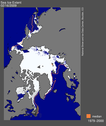 A faulty sensor has caused a slowly growing underestimation of Arctic sea ice extent by the National Snow and Ice Data Center (NSIDC). The underestimation reached approximately 500,000 square kilometers (193,000 square miles) by mid-February.
 The problem arose from a malfunction of the satellite sensor. Sensor drift, although infrequent, does occasionally occur.
The daily updates of sea ice coverage rely on rapid acquisition and processing of data from a series of Special Sensor Microwave/Imager (SSM/I) sensors. Because the acquisition and processing are done in near-real time, NSIDC publish the daily data essentially as is. The data are then archived and later subjected to quality control.
"Some people might ask why we don't simply switch to the EOS AMSR-E sensor." said the center. "AMSR-E is a newer and more accurate passive microwave sensor. However, we do not use AMSR-E data in our analysis because it is not consistent with our historical data...There is a balance between being as accurate as possible at any given moment and being as consistent as possible through long time periods."
Arctic sea ice reflects sunlight, keeping the polar regions cool and moderating global climate. According to scientific measurements, Arctic sea ice has declined dramatically over at least the past thirty years, with the most extreme decline seen in the summer melt season.
Further Reading: National Snow and Ice Data Center
What do you think of this news item? Join a discussion.
Labels: environment, SCUBA News
Tuesday, February 17, 2009
When fish farms are built along the coast, where does the waste go?
 If you are a fish eater, it's likely that the salmon you had for dinner was not caught in the wild, but was instead grown in a mesh cage submerged in the open water of oceans or bays. Fish farming, a relatively inexpensive way to provide cheap protein to a growing world population, now supplies, by some estimates, 30 percent of the fish consumed by humans.
 Two hundred and twenty species of finfish and shellfish are now grown in farms.
Intuitively, it seems a good idea—the more fish grown in pens, the fewer need be taken from wild stocks in the sea. But marine aquaculture can have some nasty side effects, especially when the pens are set near sensitive coastal environments. All those fish penned up together consume massive amounts of commercial feed, some of which drifts off uneaten in the currents. And the crowded fish, naturally, defecate and urinate by the tens of thousands, creating yet another unpleasant waste stream.
The wastes can carry disease, causing damage directly. Or the phosphate and nitrates in the mix may feed an algae bloom that sucks the oxygen from the water, leaving it uninhabitable, a phenomenon long associated with fertilizer runoff.
It has been widely assumed that the effluent from pens would be benignly diluted by the sea if the pens were kept a reasonable distance from shore, said Jeffrey Koseff, a professor of civil and environmental engineering and co-director of Stanford's Woods Institute for the Environment. But early results from a new Stanford computer simulation based on sophisticated fluid dynamics show that the icky stuff from the pens will travel farther, and in higher concentrations, than had been generally assumed, Koseff said.
"What we've basically debunked is the old adage that 'The solution to pollution is dilution,' " he said. "It's a lot more complicated."
The computer modelling (with new Stanford software that goes by the acronym SUNTANS) was conducted by Oliver Fringer, an assistant professor of civil and environmental engineering. He created a virtual coastal marine area resembling California's Monterey Bay.
Previous software, he said, has not been up to the task of accurately predicting where the unhealthy effluent from fish pens will end up, and should probably not be used by state or federal regulators when they approve locations for fish farms.
Existing software is typically derived from models that attempt to describe the drift of effluent from sewage outfall pipes, even though the substances and situations are different from fish farms. (Sewage outflow, for example, is often warmer than the ocean water.)
The fine details of modeling the flow of dissolved fish poop from a submerged cage are not as simple as they may seem. The design of the cage itself can affect the outcome. How much of the current flows through the cage, and how much goes around? Does the moving water swirl into eddies at the edges of the pen? Even the effects of the rotation of the earth on the waste plume comes into play.
The fish farmer would prefer that currents flush out his pens frequently, but as those currents take out the garbage they might unfortunately deliver it to a mangrove ecosystem or a public beach. On the other hand, insufficient flow through the pen can create a "dead zone" on the ocean floor as the fecal matter and uneaten food pile up beneath the fish.
Fringer is designing his software so that it can be used to asses any site—Puget Sound, perhaps—where sufficient digital mapping of the area already exists. SUNTANS comes just in time, said Stanford oceans expert Rosamond Naylor, as federal and local officials begin spelling the details of new health and environmental regulations for fish pens.
Further Reading:
EurekAlert
-
What do you think of this news item? Start a discussion.
Labels: environment, fish, SCUBA News
Monday, February 16, 2009
Ocean Survey Finds Identical Species at each Pole
Hundreds of species live in both polar seas, despite an 11,000-kilometer distance in between. So finds the census of Marine Life.
Among many other findings, the scientists also documented evidence of cold waterloving species shifting towards both poles to escape rising ocean temperatures.
“The polar seas, far from being biological deserts, teem with an amazing quantity and variety of life,” says Dr. Ian Poiner, Chair of the Census Scientific Steering Committee.
Researchers say smaller marine species are replacing larger ones in some Arctic waters. The reasons behind the shift are obscure but the implications for the Arctic food web may be profound.
New technologies are dramatically speeding Census research into the abundance, diversity and distribution of marine biodiversity. Census researchers are using cell phone-like devices to learn about the distribution of large animals at both poles. For example, tracking devices fitted to narwhals, to record their Arctic migrations and provide as a byproduct a wealth of rich data on the status of polar oceans. SCUBA divers were deployed for observations in heavy Arctic ice and advanced, deep water optical systems on Remotely Operated Vehicles (ROVs) enabled detailed studies of delicate marine animals too fragile to collect. And DNA sequences, or barcodes, will dramatically accelerate the cataloguing of life’s diversity, helping to identify new and cryptic species.
The polar marine explorers were startled when molecular techniques revealed that glacial cycles over millions of years made the Antarctic the cold incubator of many species residing today in more northern waters.
Scientist theorise that the Antarctic regularly refreshes the world’s oceans with new varieties of sea spiders, isopods (crustaceans related to shrimp and crabs) and others. They believe the new species evolve when expansions of ice cloister Antarctica; when the ice retreats, they radiate northward.
Previously thought to be low in species diversity and abundance, researchers have amassed biological data from nearly 1 million locations. Those places include seafloors exposed to light for the first time in as much as 100,000 years when ancient ice shelf lids melted and disintegrated in recent years.
Further Reading:
Census of Marine Life
-
What do you think of this news item? Start a discussion.
Labels: environment, research, SCUBA News
Monday, February 09, 2009
EU launches shark protection plan
 The European Commission has launched a Plan of Action for the Conservation and Management of Sharks. The aim is to rebuild shark stocks and to set down guidelines for the sustainable management of the fisheries, including where shark are taken as by-catch. The plan also hopes to increase knowledge of shark stocks and shark fisheries.
European Commissioner for Maritime Affairs and Fisheries Joe Borg commented: "Sharks are very vulnerable to over-exploitation and the consequences of depleting their numbers may have very serious consequences not only for sharks but also for marine ecosystems and for fishermen themselves. That is why we have set out a plan of action which will both establish a more precautionary approach to managing fisheries where sharks are caught, and support the substantial research still needed to understand fully the role sharks play in the life of our oceans and the impact which fishing may have on them."
The Action Plan includes measures to improve data collection and to further reinforce control of the shark finning ban, which came into force in EU waters, and for all EU vessels wherever they fish, in 2003.
The Plan covers all cartilaginous fish – not only sharks, but also skates, rays and chimaeras, which make up over 1,000 species in total. They are found throughout the world, and particularly in the Northern Atlantic Ocean, where more than 50% of shark catches by EU vessels are made. Shark fisheries have grown rapidly since the mid-1980s, driven by an increased demand for shark products (fins in particular). But these species are especially vulnerable to overfishing, since they are long-lived, slow to reach sexual maturity, have long gestation periods and a low fertility rate. A recent study by the International Union for the Conservation of Nature suggests that as many as one-third of the shark species caught in EU waters are currently threatened by excessive fishing pressure. Despite the fragility of these stocks, and their growing importance to the EU fleet, EU shark fisheries have never been managed systematically.
Environmentalist organisations have broadly welcomed the plan. Steven Broad, Director of TRAFFIC, the wildlife trade monitoring network, commented "The commitment to shark conservation is to be commended, although TRAFFIC and WWF are deeply concerned that some of the measures will not be implemented for considerable periods".
Although the Plan calls for countries to collect information on sharks caught, this will be on a voluntary basis.
TRAFFIC and WWF also called on the EU to allocated adequate resources to ensure the Plan could be properly implemented, and for the Council and the European Parliament to adopt the plan without diluting the proposed measures or extending the period of implementation.
"Many of these species are already threatened with extinction. WWF and TRAFFIC are dismayed that the plan lacks a solid commitment to seek mandatory collection of data on shark catch—a critical element if the EU is to succeed in the conservation of these species," said Dr Susan Lieberman, WWF International's Species Programme Director.
Shark Alliance Policy Director, Sonja Fordham, said “The release of the long-awaited EU Shark Plan represents a great step forward for the conservation of sharks in European waters and beyond. The Plan’s commitments to science-based fishing limits, endangered species protection, and a stronger finning ban are essential to securing a brighter future for some of Europe’s most vulnerable and neglected animals.”
“The success of the EU Shark Plan depends on prompt, follow-up proposals from the Commission and cooperation from Member States in ensuring improvements are accepted and enforced,” added Fordham. “We urge all EU Fisheries Ministers to actively support timely implementation of the Shark Plan in line with scientific advice and the precautionary approach.”
Sharks are targeted by UK, French, Spanish and Portuguese fishermen; shark tails and meat are used to prepare "caldeirada" or "Schillerlocken" and shark meat is served in restaurants across Europe, and in the UK in traditional fish-and-chip shops.
Further Reading:
European Commission Fisheries
What do you think of this news item? Start a discussion.
Labels: environment, Europe, Mediterranean, SCUBA News, sealife, sharks
Wednesday, February 04, 2009
Explore the oceans in Google Earth
 Google has launched Ocean in Google Earth, a new feature that lets you explore underwater in 3D and browse ocean-related content. The new version of Google Earth also lets you virtually travel back in time through archival satellite and aerial imagery.
 Ocean in Google Earth combines sea floor terrain and expert content to provide you with an opportunity to explore some of the most difficult-to-reach parts of the world. Virtual travellers to Hawaii, for example, can examine underwater volcanoes, see videos about the marine life of the region, read about nearby shipwrecks and contribute photos and videos of favorite surf spots.
"With this latest version of Google Earth you can not only zoom into whatever part of our planet’s surface you wish to examine in closer detail, you can now dive into the world’s oceans that cover almost three-quarters of the planet and discover new wonders that had not been accessible in previous versions of this magical experience," said Al Gore at the launch event in San Francisco. "Moreover, with the new historical imagery feature, you can look back in time and see for yourself the unprecedented pace of change taking place on the Earth — largely because of human influences. For example, you can watch the melting of the largest glacier in Glacier National Park—the Grinnell Glacier—image by image, for the last decade."
To find the new Google Ocean go to http://earth.google.com/ocean/.
What do you think of this news item? Start a discussion.
-
Labels: SCUBA News
![]()